The global geospatial solutions market is expected to expand significantly, from USD 626.13 billion in 2024 to USD 2,155.72 billion by 2034, at a CAGR of 13.16%. Similarly, the global downstream GNSS (Global Navigation Satellite Systems) market-encompassing both device and service revenues-is expected to increase from approximately €260 billion in 2023 to €580 billion by 2033, reflecting a CAGR exceeding 8%.
Key insights include:
- Service Revenues as Growth Drivers: Service revenues are expected to reach €460 billion by 2033, accounting for nearly 80% of the GNSS downstream market. This shift signals the growing importance of software and services over hardware devices in driving market growth.
- Smartphone Applications at the Core: Revenues from smartphone applications represent over 60% of added-value services and more than 40% of total market revenues.
- Emerging Opportunities in Advanced Applications: Innovations in autonomous vehicles, climate monitoring, and spoofing detection are projected to unlock over $10 billion in market opportunities by 2030, highlighting the growing importance of high-precision geospatial data.
- Dependence on Geospatial Data Across Industries: Sectors such as autonomous vehicles, precision agriculture, space exploration, smart cities, and defense are leveraging geospatial solutions for operational efficiency and innovation. For instance, autonomous vehicles require ultra-accurate navigation, while precision agriculture depends on detailed geospatial insights to enhance crop yields.
Traditional satellite-based navigation systems-such as GPS (USA), Galileo (Europe), BeiDou (China), and GLONASS (Russia)-rely on constellations of satellites transmitting signals to ground receivers. However, these systems face limitations, including atmospheric interference and satellite time synchronization errors, which restrict location accuracy to within 10–20 feet. This level of precision is insufficient for advanced applications like precision farming and complex surveying.
The companies highlighted in the following sections are driving innovative solutions to these challenges, utilizing blockchain technology and the Decentralized Physical Infrastructure Networks (DePIN) model.
Geodnet
Core Team: Mike A. Horton, David Chen, Yudan Yi, Melissa Nguyen
TGE (Token Generation Event): Sep 7, 2023
Funding Insights:
Private Token Sale - Date: 6 Jul 2023 | Amount Raised: $1.50M
Selected Investors: Borderless Capital (Lead), IoTeX
Undisclosed Round - Date: 27 Feb 2024 | Amount Raised: $3.50M
Selected Investors: North Island Ventures (Lead), Borderless Capital, IoTeX, Reverie, Modular Capital, Tangent, JDI, Road Capital
Strategic Round - Date: 16 Apr 2024 | Amount Raised: $2.00M
Selected Investors: Pantera Capital, CoinFund, Santiago R. Santos, VanEck
Undisclosed Round - Date: 29 Oct 2024 | Amount Raised: Undisclosed
Selected Investors: Animoca Brands
GEODNET leverages blockchain technology to establish a decentralized, scalable real-time kinematic (RTK) network. This approach ensures cryptographic guarantees for data transmission, secure location services, and data ownership authenticity while incentivizing global network expansion through an tokenomics framework.
Key Features
Decentralized RTK Network
GEODNET utilizes GNSS base stations, referred to as space weather miners, to:
- Provide precise location corrections for GPS, GLONASS, Galileo, and BeiDou systems.
- Generate and validate geospatial data while mining GEOD tokens.
Community-Driven Global Expansion
SuperHex Program:
- Identifies high-priority regions, referred to as "SuperHexes," where GEOD tokens are staked to activate GNSS mining station deployment.
- The first station in each SuperHex receives up to 4x token rewards, accelerating coverage expansion.
Tokenomics Overview
GEOD Token Details
Total Supply: Capped at 1 billion tokens.
Reward Schedule:
- 07/01/2023 - 06/30/2024: 48 GEOD/day
- 07/01/2024 - 06/30/2025: 24 GEOD/day
- 07/01/2025 - 06/30/2026: 12 GEOD/day
Token Unlock Mechanism
- Mining rewards are unlocked daily for GNSS miners.
- Allocations to the team, investors, and ecosystem undergo a multi-year locking schedule, maintaining long-term economic stability.
Multi-Chain Accessibility
GEOD tokens are deployed across multiple blockchains to enhance usability: Polygon; Solana; IoTeX
Product Comparison
GEODNET provides decentralized GNSS correction data, offering unmatched affordability and accuracy:
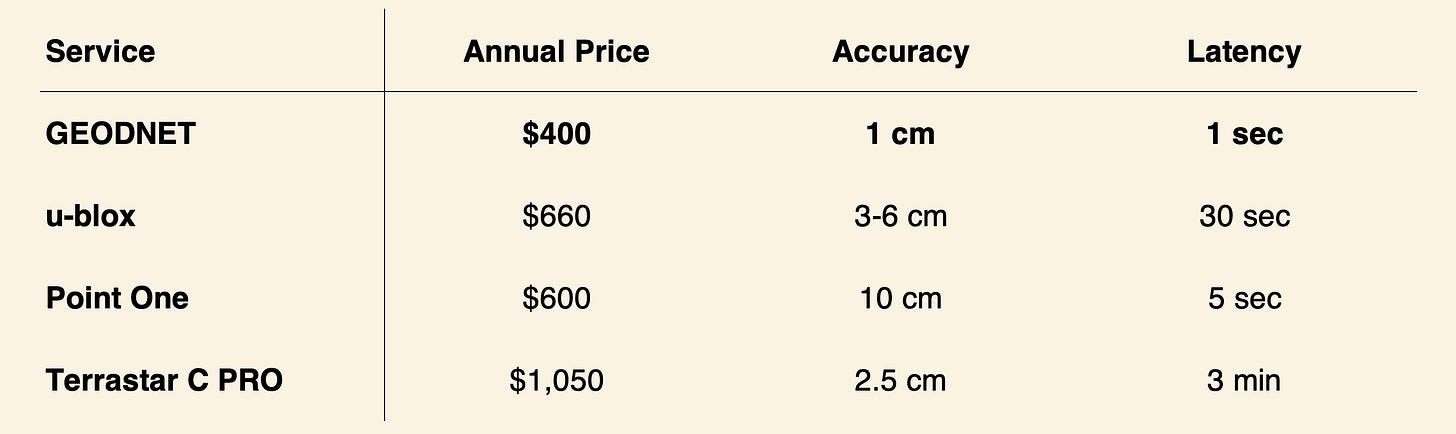
Key Advantages: Price: $400/year, Accuracy: Sub-centimeter precision (1 cm), exceeding competitors, Latency: Near-instantaneous updates (1-second latency).
New Product: GEO-PULSE
- Launch Date: November 20, 2024.
- Overview: A GPS device offering sub-0.1-meter accuracy at $129 (includes one-year GEODNET service).
- Features: GEO-PULSE reduces navigation errors globally, connects seamlessly with iOS/Android for precise turn-by-turn directions, rewards users with cryptocurrency via the Quest app, and supports developers with an SDK (available Q2 2025) and blockchain integration for decentralized applications.
Key Risks
GEODNET faces competition from incumbents like Trimble and emerging technologies (e.g., 6G), potential challenges in tokenomics (declining rewards risking network growth), and legal/security concerns, including uncertain buyback legality and risks of hacking or data misuse.
Geodnet Key Metrics
Miners - Total Miners: 10,630 | Countries: 140 | Cities: 4,073
Total Tokens Issued: 105,361,942 GEOD
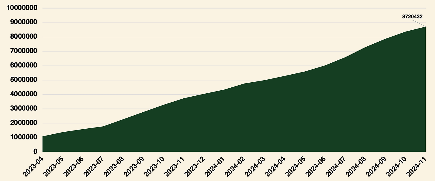
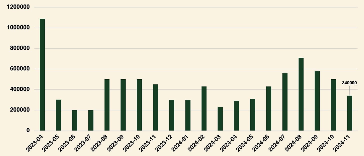
Total GEOD Burned: 8,720,432 tokens | Cumulative USD Burned: $989,147.30
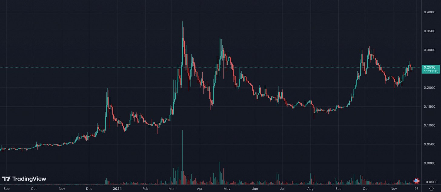
GEOD/USD - $0.253 (12:30 PM UTC; Nov 21, 2024); MC - $50.2M
Onocoy
Core Team: Daniel Ammann, Thomas Nigg
Funding Insights:
Private Token Sale - Date: 3 Sep 2024 | Amount Raised: $940.00K
Selected Investors: Smart Island Capital, Thomas Seiler (Former CEO of u-blox for over 20 years)
Daniel Ammann and Thomas Nigg, the founders of Onocoy, bring over two decades of expertise gained at u-blox AG (SIX: UBXN, Market Cap ~USD 0.5 billion)-a global leader in semiconductor chips, modules, and IoT services for reliable location and connectivity solutions. Daniel, a co-founder of u-blox, held key executive roles, while Thomas led product development and marketing efforts.
Despite its transformative potential, high-precision GNSS positioning remains largely inaccessible to the broader market due to the absence of a global, dense, and optimally distributed GNSS reference network. Existing infrastructure is fragmented, cost-intensive, and concentrated in affluent regions, creating barriers to innovation in essential applications such as disaster response, autonomous navigation, and climate monitoring.
How Onocoy Works
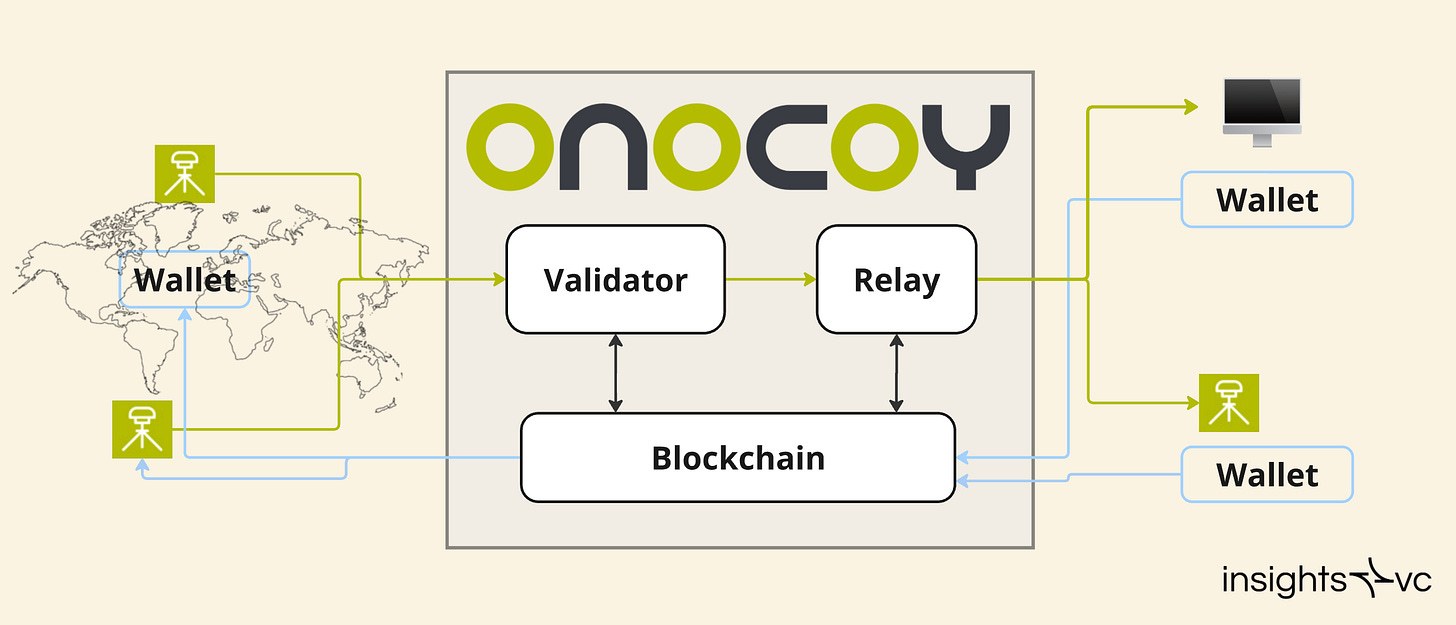
Onocoy’s IT infrastructure
- Decentralized GNSS Network: Onocoy leverages blockchain-based incentives to build a community-powered GNSS reference station network, enabling sub-centimeter accuracy in real-time.
- Open Standards & Interoperability: By embracing RTK and PPP protocols, Onocoy ensures compatibility with existing systems, avoiding vendor lock-in and facilitating mass-market adoption.
- Validation Framework: GNSS data from reference stations is rigorously validated using statistical and physical consistency checks to prevent fraud and maintain data integrity.
Tokenomics
Dual-Token Model:
- ONO Token: A deflationary, tradeable utility token used to purchase data credits and incentivize network participants.
- Data Credits: Non-transferable tokens pegged to fiat for predictable service pricing, used exclusively to access GNSS correction data.
- Incentive Structure: Miners and validators earn ONO tokens based on data quality, availability, and geographic diversity, with rewards adjusted over time via a halving mechanism.
Value Proposition
- Cost Efficiency: Decouples infrastructure management from service provision, reducing redundancy and cost barriers for stakeholders.
- Global Accessibility: Democratizes access to high-precision GNSS services, particularly in underserved regions like Africa and South America.
- Synergies Across Stakeholders: Enables existing GNSS providers to expand cost-effectively while fostering a collaborative ecosystem for new entrants.
Roadmap
Current Status: Early product rollout on Solana blockchain with functional pay-per-use RTK correction streams.
Future Goals:
- Progressive decentralization of validators and communication infrastructure.
- Expansion of miner and validator participation globally.
- Development of novel applications such as indoor navigation and advanced disaster monitoring systems.
Spexi
Core Team: Bill Lakeland (CEO), Alec Wilson (COO), Peter Szymczak (CTO), Michael Claassen (VP Product)
Funding Insights:
Seed Round - Date: 4 Oct 2022 | Amount Raised: $5.50M
Selected Investors: Blockchange Ventures (Lead), Dapper Labs, Alliance DAO (Incubator), Protocol Labs, FJ Labs, InDro Robotics, CyLon Ventures, Vinny Lingham, Adam Jackson
Problem
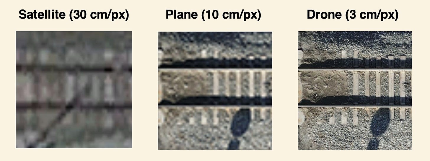
Side-by-side graphic showing the quality of drone imagery vs. legacy imagery
The aerial imagery market relies on costly, low-resolution legacy solutions like satellites and aircraft:
- Resolution limitations: Satellites offer only 30cm/pixel, inadequate for many use cases.
- High costs: Planes and helicopters require investments exceeding $2M for equipment and operations.
- Low drone utilization: Despite offering 10x better resolution and lower costs, drones have imaged less than 1% of Earth's landmass due to fragmented standards, high costs, and complex regulations.
Solution
Spexi Network leverages drones to create a decentralized platform for ultra-high-resolution aerial imagery:
- Affordable: Consumer drones ($500+) deliver data at a fraction of traditional costs.
- Standardized: The "Spexigon" grid system enables consistent data collection worldwide.
- Incentivized: Pilots earn rewards via the FLY TO EARN model by collecting imagery and uploading it to the blockchain-verified platform.
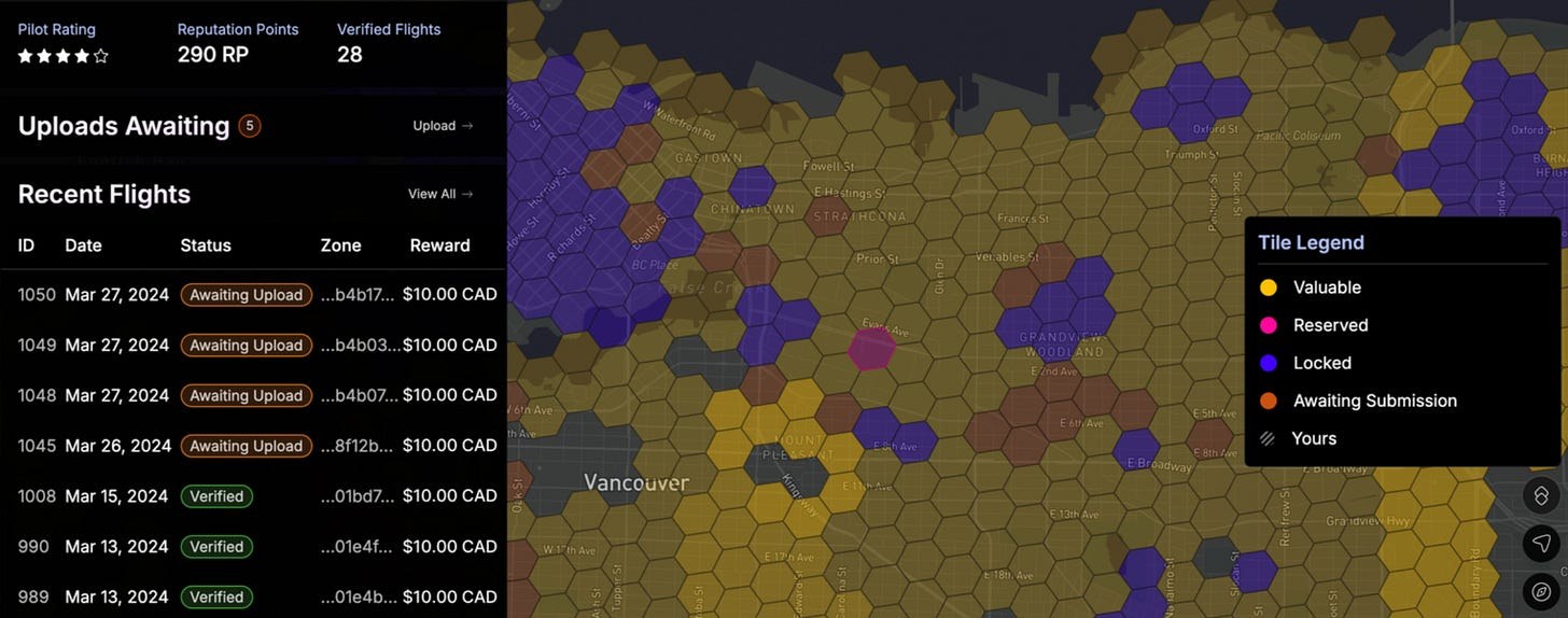
The Spexi Explorer showing different types of spexigons in an open region
Market Opportunity
In recent years, an increasing number of companies, such as AI Clearing, have emerged, specializing in digital field construction progress tracking. Data is collected using drones, and such solutions significantly reduce costs while mitigating litigation risks.
The aerial imagery market is a multi-billion-dollar sector with applications in:
- Emergency Response: Identifying wildfire risks, monitoring floods, and disaster planning.
- Mapping and Navigation: Supporting self-driving cars, AR/VR gaming, and last-mile delivery.
- Infrastructure and Construction: High-resolution data for urban planning, inspections, and progress monitoring.
- Insurance and Real Estate: Remote evaluation for underwriting and enhanced property marketing.
Tokenomics
Spexi plans to launch the SPEXI token, a utility token designed to incentivize pilots and drive network growth.
During the Testnet phase, pilots earn Reputation Points (RPs) and cash rewards, with future rewards transitioning to SPEXI tokens. RPs allow pilots to reserve exclusive Spexigons and participate in staking for preferential access. A reputation system promotes quality by rewarding successful contributions and penalizing failures.
Roadmap
Alpha Phases (2023): Internal testing in Canada with professional pilots.
Beta Testnet (2024): Public beta launching Q4 2024, expanding to pilots in Canada and the U.S. | Pilots earn RPs and cash rewards for verified imagery uploads.
Mainnet Launch (early 2025): Full-scale platform with SPEXI token rewards and international availability.
We focused on the latest initiatives in this category, but we also recommend exploring the FOAM. Rooted in the ICO boom of 2017, FOAM has been steadily developing its concept in the geospatial category since then.
Docs/Whitepaper links:
Sources:
- https://www.euspa.europa.eu/sites/default/files/euspa_market_report_2024.pdf
- https://cryptorank.io/
- https://dune.com/geodnet_console/
Cover Artwork

Snowdon from Llyn Nantlle
Richard Wilson c.1765–1767
Risk Disclaimer:
insights4.vc and its newsletter provide research and information for educational purposes only and should not be taken as any form of professional advice. We do not advocate for any investment actions, including buying, selling, or holding digital assets.
The content reflects only the writer's views and not financial advice. Please conduct your own due diligence before engaging with cryptocurrencies, DeFi, NFTs, Web 3 or related technologies, as they carry high risks and values can fluctuate significantly.